Weather Satellite Imaging

May 2006
The goal of this project was to develop a weather station capable of receiving and processing weather satellite signals into readable images. The system in this project consists of a Quadrifilar Helix antenna, a pre-amplifier, a receiver and a PC sound card. The recorded audio signal was decoded using Matlab.
This project was completed as an Electrical Engineering Senior Project at the University of Kansas (Lawrence, KS) in May 2006. Our design team consisted of myself, Kawaya Swana Eric Mbaka, Vijo Varghese and Bill Dower (pictured left to right above).
Extended Description
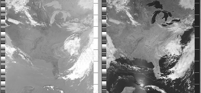
Low Earth Orbiting (LEO) satellites complete an orbit over the Earth’s poles at an altitude of 840 kilometers every 104 minutes. Currently, there are 4 operational NOAA satellites that orbit and send signals: NOAA-15, NOAA-16, NOAA-17 and NOAA-18 (Current Status). These satellites use cameras to scan the visible spectrum as well as the infrared spectrum and take strips of images that span approximately 3000 km. This is done repeatedly to make a continuous image, which is then transmitted continuously on the 137 MHz frequency band. This signal can be received while the satellite is overhead, which can last up to 15 minutes. The Quadrifilar Helix antenna (QFH) is regarded as one of the best antennas to receive this signal.
Downloads
- Full Project Report (PDF)
- Project Poster (PDF)
- NOAA APT Audio Sample, 5 seconds, 10 APT frames in Length (.mp3 file)
- Full 15 minute uncompressed sample NOAA APT signal with decoded images (29 MB zip file)
- Matlab Decoding Code
Resources:
- Similar Projects
- Receiving weather satellite images with Softrock http://alternet.us.com/?p=1398
- NOAA Satellite Info
- NOAA-N Satellite Booklet
- NASA GOES POES Program http://goespoes.gsfc.nasa.gov/poes/index.html
- NOAA KLM User's Guide http://www2.ncdc.noaa.gov/docs/klm/
- Satellite Tracking
- NOVA tracking software http://www.nlsa.com/index.html
- Receiver
- Satellite Imaging
- Remote Imaging Group http://www.rig.org.uk/
- Antenna Design
- Quadra-helix Antenna http://www.qsl.net/kf4cpj/qha/
- Antenna http://homepage.ntlworld.com/phqfh1/qfh_diy_guide.htm
- WXSat QFH Antenna http://www.frars.org.uk/cgi-bin/render.pl?parameter=&pageid=1154
- Design http://perso.wanadoo.es/dimoni/ant_qha.htm
- LNK Receiver Pre-amp from Hamtronics http://www.hamtronics.com/
- Signal Processing
- NOAA Signal Specs http://www2.ncdc.noaa.gov/docs/klm/html/c4/sec4-2.htm/
- WXtoImg Imaging Software http://www.wxtoimg.com/
- WXSat Imaging Software http://hffax.de/html/hauptteil_wxsat.htm
- Wavepad Audio Software http://nch.com.au/wavepad/masters.html
- APT Decoder http://www.ptast.com/apt/decoder/
Media: